This is a map from Sebastian Munster of North and South America, which was published in his edition of Ptolemy's Geographia and in Cosmographia in 1544. I find this map interesting because I think it is amazing how people from back then were able to get a general idea of how the lands looked like without the use of technology like we have today.
Source:
Munster, Sebastian. Munster's Map of the World - 1544. N.d. Map. n.p. Web. 2 Oct 2012. <http://floridahistory.com/us@1544.html>.
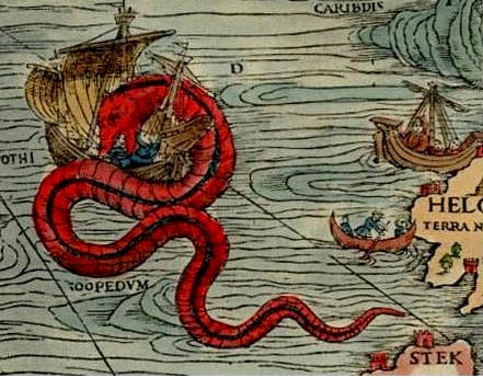
I got this map from a blog by cantueso of a map from sailors who drew it based on their experiences from sailing, but the geography is incorrect. I think it is amusing how sailors would exaggerate what happens at sea, they make up pictures about things that they are unfamiliar about or maybe to scare other sailors away from certain parts of the map to protect their hidden treasure.
Source:
cantueso. Old Sea Maps with Monsters. 2008. Map. wordpress.com Web. 2 Oct 2012. <http://espliego.wordpress.com/2008/01/08/old-sea-map-with-monsters/>.
This is a map by Maria Rabinky from Wikipedia.org of an aerial map illustrated with a contemporary illustrative technique. I think this map is interesting because I like how it is really detailed at some parts of the map and not as much in others, and I think the colors make the map really nice to look at. I think it shows that the artist wants to emphasize the areas where they are familiar with and it acts sort of like a list of recommended places to visit.
Source:
Rabinky, Maria. Tampa Bay Aerial Map. 2008. Map. wikipedia.org Web. 2 Oct 2012. <http://en.wikipedia.org/wiki/Pictorial_maps>.


No comments:
Post a Comment